Good evening to you from Southern Connecticut Weather!
As Don talked about last night, we’ve got a light snow event on our hands for tomorrow, with the core of the snow focused around the evening commute. An Alberta Clipper dives south out of Canada and across the Northeast before redeveloping as an inverted trough just offshore of eastern New England. While significant totals are not expected, there is good lift in place and snow ratios will be fairly high, and so while rates will be fairly light, we should be able to stack up a couple inches of fluff for most of the state.
Models and Trends
Guidance is in excellent agreement with the overall track of the event. The clipper system comes down through the lakes overnight tonight into tomorrow, reaching the south coast by early afternoon. As the area of best lift works its way northward, expect snow to move steadily north throughout the afternoon, with snow across most of the state in time for the evening commute.
The system then redevelops off the coastline and spawns a weak inverted trough, moving the area of precipitation north a bit. Snow will likely taper off in southern areas later tomorrow evening, but further north, depending on the eventual orientation of the trough, light snow could persist through the overnight and possibly into the morning commute on Wednesday before tapering off.
As far as QPF goes, generally, it looks like between a tenth and a quarter of an inch of QPF will fall with the initial clipper, with the higher end of that range likely reserved for areas where the best banding forms. The American models along with the UKMET are a little more bullish than the rest of the foreign guidance, but the general consensus is strong.
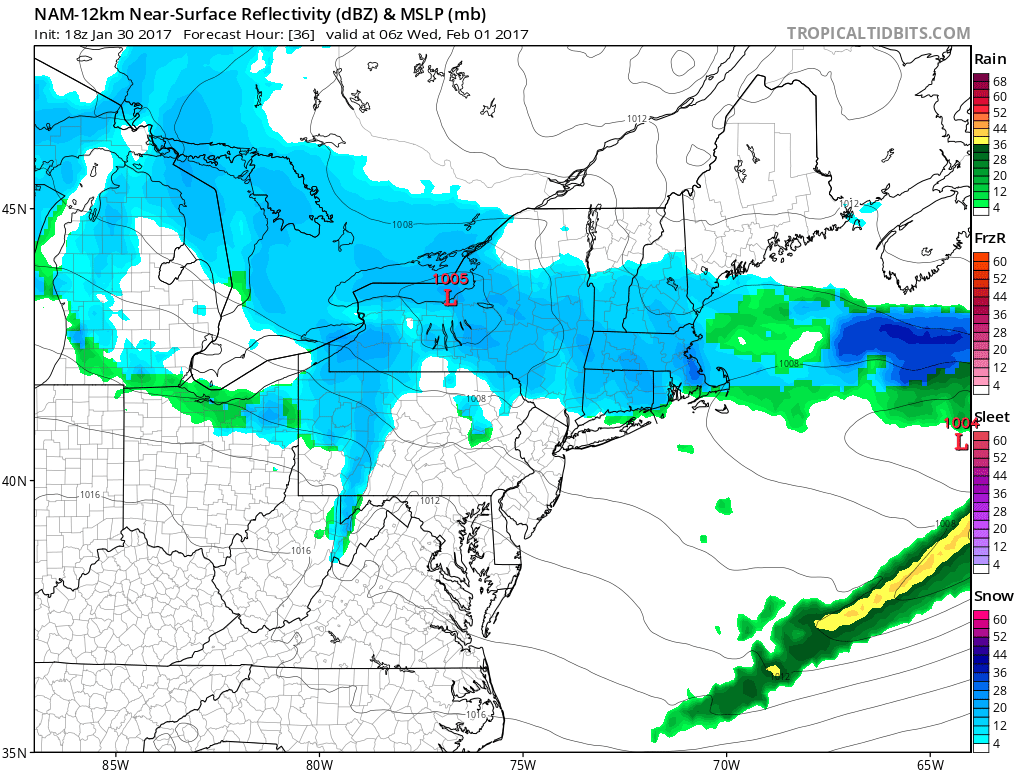
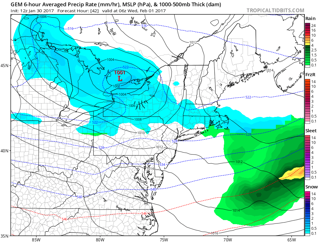
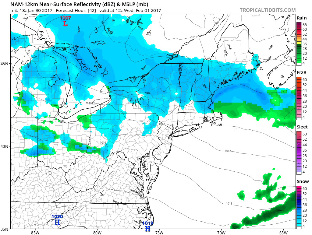
Here’s a look at the 18z NAM, representing the stronger end of the model spectrum, and the 12z GGEM, representing the weaker end, as well as the NAM later on tomorrow night to show the inverted trough - notice the enhanced area of echoes in northeast MA there.
As Don talked about last night, we’ve got a light snow event on our hands for tomorrow, with the core of the snow focused around the evening commute. An Alberta Clipper dives south out of Canada and across the Northeast before redeveloping as an inverted trough just offshore of eastern New England. While significant totals are not expected, there is good lift in place and snow ratios will be fairly high, and so while rates will be fairly light, we should be able to stack up a couple inches of fluff for most of the state.
Models and Trends
Guidance is in excellent agreement with the overall track of the event. The clipper system comes down through the lakes overnight tonight into tomorrow, reaching the south coast by early afternoon. As the area of best lift works its way northward, expect snow to move steadily north throughout the afternoon, with snow across most of the state in time for the evening commute.
The system then redevelops off the coastline and spawns a weak inverted trough, moving the area of precipitation north a bit. Snow will likely taper off in southern areas later tomorrow evening, but further north, depending on the eventual orientation of the trough, light snow could persist through the overnight and possibly into the morning commute on Wednesday before tapering off.
As far as QPF goes, generally, it looks like between a tenth and a quarter of an inch of QPF will fall with the initial clipper, with the higher end of that range likely reserved for areas where the best banding forms. The American models along with the UKMET are a little more bullish than the rest of the foreign guidance, but the general consensus is strong.
Here’s a look at the 18z NAM, representing the stronger end of the model spectrum, and the 12z GGEM, representing the weaker end, as well as the NAM later on tomorrow night to show the inverted trough - notice the enhanced area of echoes in northeast MA there.
While we saw a fairly strong trend yesterday to strengthen the system a bit, today’s trends have been a bit murkier, with the various models bouncing around a bit but generally remaining consistent when a consensus blend is taken. As such, confidence levels are fairly high with the clipper portion of the system. With the IVT, confidence is lower, as they are notoriously fickle and difficult to model. The general rule is that they will often verify a bit north and east of where the models place them, which would take northern portions of our forecast area out of the target area, but some rules are made to be broken, and this one is no exception. As such, while I think it is relatively unlikely, a small shift south with the placement of the inverted trough could result in a couple of tenths more QPF for the northern portion of the state, which would bring total QPF into the third to half an inch range – enough for a moderate to low end significant snowfall. Low probability, but worth keeping an eye on.
Looking at snow ratios, algorithms such as the Kuchera method suggest ratios of around 13:1 in northern areas and 10:1 in southern areas. This passes the “sniff test”, as we’ll see temps near 32 along the coastline and a bit cooler inland. Some of the heavier banding could have higher ratios, but not confident enough in that at this time to go any higher.
Forecast and Timing
Here’s a look at our forecast snowmap for this event.
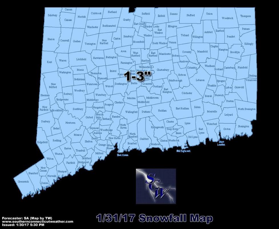
Overall, this is a fairly classic Alberta clipper, with a relatively uniform area of light snows. I do think that there will be a slight latitudinal gradient to the system, with northern areas probably coming in towards the higher end of the range due to higher snow ratios and the potential for some bonus snow from the inverted trough, but wasn’t confident enough in that to go for a 2-4” zone for the northern tier, although we will probably see a few totals in the 4” range where the best banding sets up. Generally though, this is a 1-3” event, and will allow the map to reflect that.
Snow will start around midday on the southwest coast and spread north and east throughout the afternoon. Snow impacts the PM commute before tapering off late evening for southern areas and by daybreak Wednesday morning in northern areas. We could see some lingering snow squalls on Wednesday, but widespread snows should wrap up by the start of the commute.
Impacts
Overall, a fairly straightforward system and a nice return to winter after our warmth the past few weeks. We’ll keep an eye on the radar tomorrow and update you as needed throughout the day. Send us your reports and photos on Facebook and on Twitter @SouthernCTWX so we know what’s happening on the ground and we may feature your photo on our social media!
Thanks for reading SCW and enjoy the snow!
-SA
Snow will start around midday on the southwest coast and spread north and east throughout the afternoon. Snow impacts the PM commute before tapering off late evening for southern areas and by daybreak Wednesday morning in northern areas. We could see some lingering snow squalls on Wednesday, but widespread snows should wrap up by the start of the commute.
Impacts
- A light to moderate snowfall – low end plowable in some areas.
- Difficult travel during the Tuesday PM commute.
- Early dismissals are possible from schools, especially along the shoreline and in western areas.
Overall, a fairly straightforward system and a nice return to winter after our warmth the past few weeks. We’ll keep an eye on the radar tomorrow and update you as needed throughout the day. Send us your reports and photos on Facebook and on Twitter @SouthernCTWX so we know what’s happening on the ground and we may feature your photo on our social media!
Thanks for reading SCW and enjoy the snow!
-SA
