Ah, spring. Birds chirping, sun shining, plants sprouting, and the general feeling of rejuvenation and relaxation. We’ve seen it in abundance the past couple of days, but, like it or not, Mother Nature has other plans for us going forward. Yes, the S word is back in the forecast, not once, but twice within the next few days. Tonight’s discussion will focus on those two opportunities, primarily focusing on the first. They are both clipper-esque systems that come on the heels of a strong arctic shot that will move into the region tomorrow evening. The first comes Sunday morning, while the second arrives right on its heels on Monday.
Storm 1: Sunday Morning
A coastal storm comes up the coastline tonight into tomorrow, bringing a round of light rain to the state and another day of warm temperatures. However, on the back side of that system, a strong arctic shot moves Saturday night, just in time for the first of two clipper systems to approach the area.
All model guidance is, shockingly, in relatively good large-scale agreement on this system. A low dives out of the northern Midwest and/or southern Canada Saturday evening, tracks due east across Pennsylvania and/or New York, and continues it’s easterly push over southern New England Sunday morning before exiting to the east. To the north of the low, a period of snow is likely, while to the south of it, some light rain, along with high winds, are expected.
However, there are several caution flags at play here with this system. The first is the strength and dynamics of the low. The strength of the shortwave, combined with the rapid changes in pressure from the coastal and arctic front, will be enough to create strong winds across the entire state, with the heaviest winds falling to the south of the low. This will result in an increased impact to visibility from whatever snow does fall. Additionally, modeling has been persistent at showing a convective-like nature to the system. Should the modeled convection play out, we would see some bands of very heavy snow forming, and while they would only last for a short time, rates would be impressive enough to leave several inches in a period as short as an hour. I do think that some very strong bands are likely, but the bigger question is where they form.
You see, when I said that models were in good agreement, it was on the large scale. As is typical for any system, there are some small discrepancies in track that still need to be resolved. However, because the impacts from this system will be very localized in nature, those small wobbles will make a big impact. Todays mid-day set of models put the axis of heaviest snow anywhere from the coastline to southern New Hampshire, with a cluster favoring the I-90 corridor of MA and just north. However, it should be noted that the trend on this system the past several cycles has been to bring it slightly further south, and should that continue, that would give more support to the solutions that jackpot Connecticut.
Here’s a look at some simulated radar maps from the midday guidance for Sunday morning. This isn’t a situation where I’d want to use these to directly forecast snowfall due to a combination of potentially high ratios, convective aspects, and generally mid-levels providing a better understanding of where heavy precipitation may develop, however, the models put their precipitation where they do for a scientific reason, and the factors I outlined above play a significant role, even if the interpretation is not as great as it could be. As such, the maps, while not providing excellent forecast value, are a good way to show the differences in track between each of the models. Here they are below. The system is moving essentially due east, so western areas would get into the precipitation in earlier frames for those models that are only 3 hour intervals.
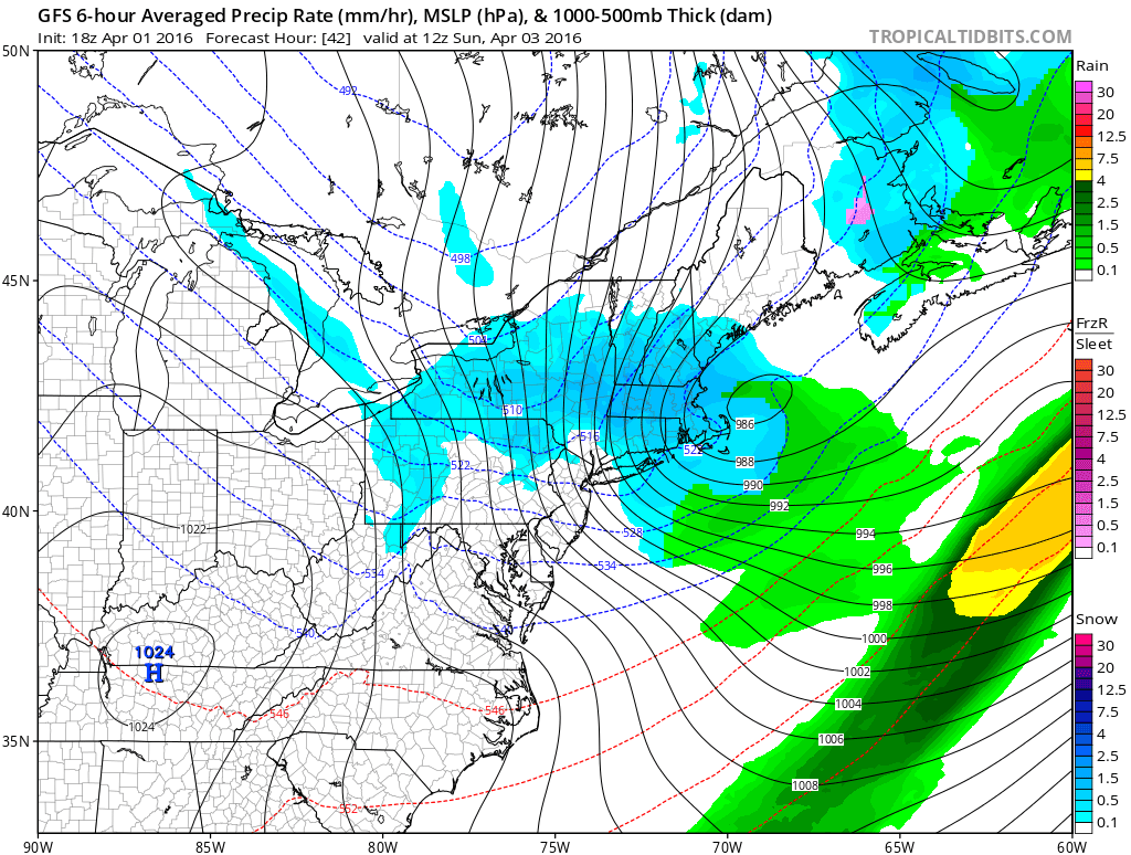

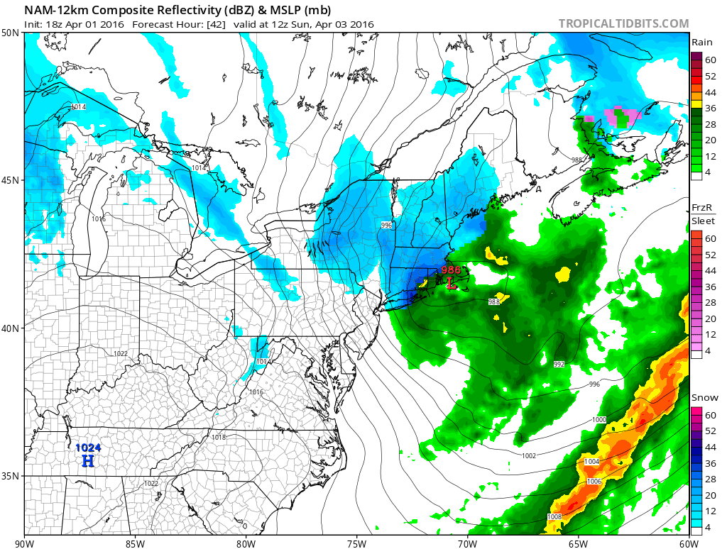
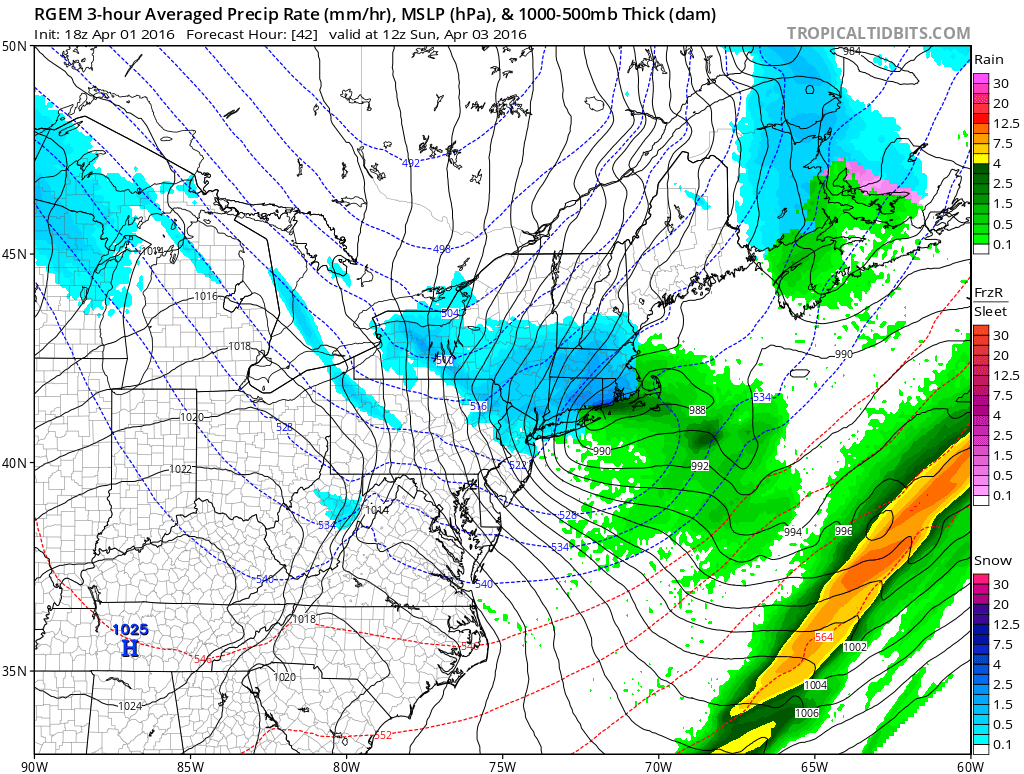
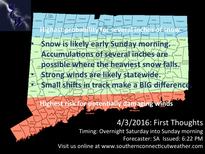
As you can see, while the precipitation shield is fairly large, the area of heavier snows (darker blues) is fairly small. Considering the temperatures will be marginal, I think that this lighter snow will struggle to accumulate along the coastline and in the CT river valley, and as such, if the stronger band tracks further north, I think those areas are out of the game for more than a slushy coating or so. Otherwise, just about anyone in the state is in the game for an advisory level(3”+) snowfall on Sunday morning, although I do not expect those totals to be widespread.
Due to the uncertainty of a convective system and the narrow area of significant snows, I have held off on issuing an accumulations map for now. Instead, I have highlighted the areas where the best chance of heavier snows and stronger winds are, and have left a general idea for the rest of the state below. A snowmap will be issued tomorrow afternoon.
Due to the uncertainty of a convective system and the narrow area of significant snows, I have held off on issuing an accumulations map for now. Instead, I have highlighted the areas where the best chance of heavier snows and stronger winds are, and have left a general idea for the rest of the state below. A snowmap will be issued tomorrow afternoon.
Snow wraps up by mid-morning Sunday, and we’ll have the afternoon off before we move to…
Storm 2: Monday
Here we go again! Another clipper moves into the area Monday morning, passing along the stalled frontal boundary from Saturday night’s arctic front. This time, the system is a bit more robust, which will result in a larger, more consistent precipitation shield. Models have generally been steady in either tracking the system directly over us or just under us, which will likely lead to snow in the northern portion of the state and a mix or rain along the shoreline. If the system trends further south, such as shown by the European model, the shoreline will be more likely to remain all or mostly snow, while a further north track will result in mostly rain across the state. For now, considering guidance has been very stable overall, I lean toward a consensus blend. Precipitation breaks out Monday morning and continues throughout the day, ending by sunset or so. I don’t see any crazy bands or insane totals with this one, but I think a widespread plowable snowfall is possible in northern portions of the state, potentially extending down to just off the shoreline depending on the eventual track of the low. Even if the shoreline remains all snow, warm surface temperatures and light rates will limit accumulations.
We will issue a first call snowmap for this system tomorrow evening, and a final call Sunday evening.
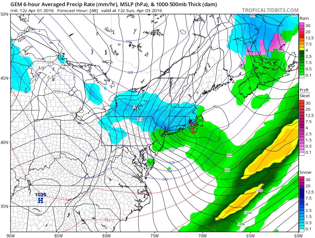
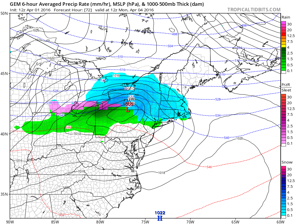
Here’s a look at the system on the Canadian model, which represents a good middle ground consensus of the solutions. Much more to come on this storm tomorrow, should it remain on guidance.
Storm 2: Monday
Here we go again! Another clipper moves into the area Monday morning, passing along the stalled frontal boundary from Saturday night’s arctic front. This time, the system is a bit more robust, which will result in a larger, more consistent precipitation shield. Models have generally been steady in either tracking the system directly over us or just under us, which will likely lead to snow in the northern portion of the state and a mix or rain along the shoreline. If the system trends further south, such as shown by the European model, the shoreline will be more likely to remain all or mostly snow, while a further north track will result in mostly rain across the state. For now, considering guidance has been very stable overall, I lean toward a consensus blend. Precipitation breaks out Monday morning and continues throughout the day, ending by sunset or so. I don’t see any crazy bands or insane totals with this one, but I think a widespread plowable snowfall is possible in northern portions of the state, potentially extending down to just off the shoreline depending on the eventual track of the low. Even if the shoreline remains all snow, warm surface temperatures and light rates will limit accumulations.
We will issue a first call snowmap for this system tomorrow evening, and a final call Sunday evening.
Here’s a look at the system on the Canadian model, which represents a good middle ground consensus of the solutions. Much more to come on this storm tomorrow, should it remain on guidance.


We’ll see you back here tomorrow afternoon for your final call on Sunday morning and then your first call for Monday! In the mean time, please don’t hesitate to ask any questions you may have, and please share this post with your network to get the word out about our upcoming return to winter. Have a great weekend and thank you for reading Southern Connecticut Weather!
-SA
-SA
