Good evening from Southern Connecticut Weather!
As many of us make final preparations to watch our beloved UConn Huskies take on the #1 Kansas Jayhawks, we continue to watch a very tricky winter weather event take shape to our south.
When I wrote our morning update today, I noted that the overnight and morning guidance had shifted east, making the potential late season winter storm far less impactful event for much of the state. If you pay attention to other weather outlets, some took it a step further, slashing snow totals after those runs.
Essentially, as soon as everyone hoisted the red flags on this event, all the guidance trended toward a more significant event. Fun times. Here’s the latest.
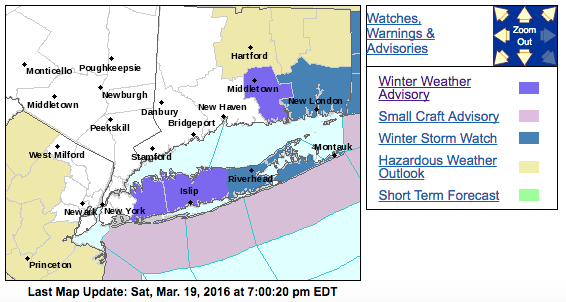
I expect watches/warnings/advisories to be expanded overnight and tomorrow morning.
The basics remain the same—we are looking at a wave of low pressure riding up the coast tomorrow into Monday, and keeping a close eye on the strength of the low, the low track, and how the midlevel development of the system contributes to the expanse and intensity of precipitation over our region.
The Models
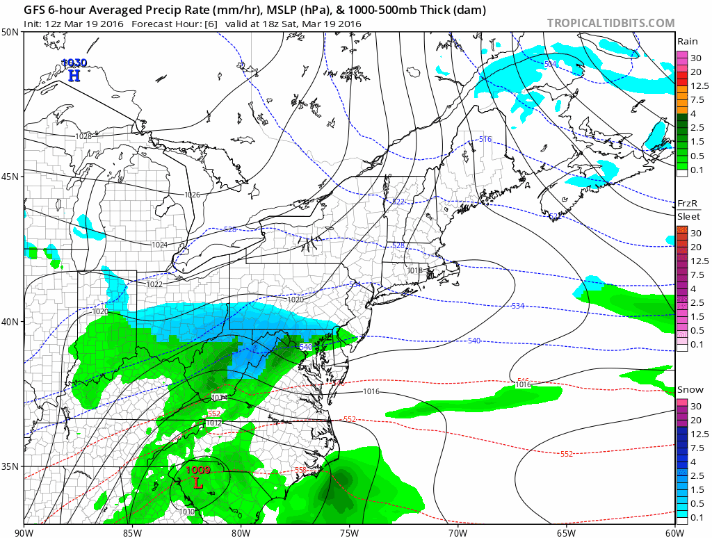
If there was ever a time where you needed to blend guidance and use your own judgment to make a forecast, this is it. Relying solely on guidance in this instance, where there are almost wild swings from suite to suite, is a recipe for disaster. Here, I’m just hoping for a semblance of consistency within a given model and across all models. Looking at the latest data, I am more confident in a significant event taking place across most of Connecticut. Let’s take a look at the morning (06z), afternoon (12z) and evening (18z) GFS. This model has been the least bullish of an event so far.
The Models
If there was ever a time where you needed to blend guidance and use your own judgment to make a forecast, this is it. Relying solely on guidance in this instance, where there are almost wild swings from suite to suite, is a recipe for disaster. Here, I’m just hoping for a semblance of consistency within a given model and across all models. Looking at the latest data, I am more confident in a significant event taking place across most of Connecticut. Let’s take a look at the morning (06z), afternoon (12z) and evening (18z) GFS. This model has been the least bullish of an event so far.

06z GFS simulation above.
12z GFS
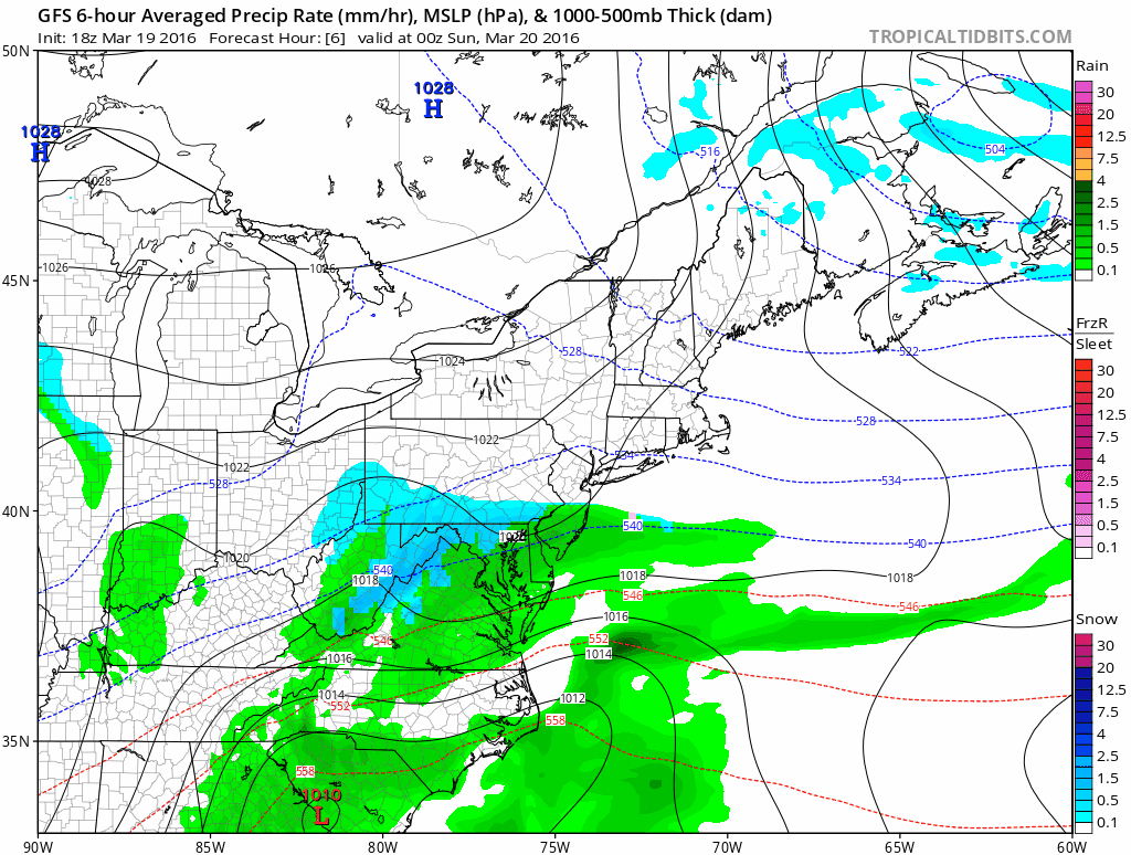
With each run, the 500mb progression is better, and with a sharper trough the low comes in more amplified, resulting with a further northwest extent of significant precipitation.
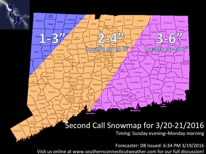
So why are we keeping the map the same if data is showing a more robust system?
Given the volatility of the guidance, we made a good call keeping our map where it was this morning. Even with guidance showing a higher impact event currently, taking numbers up or down doesn’t make much sense, as our map remains the most likely outcome right now.
I will say however, that this map likely represents a floor of the event’s potential rather than a ceiling. We are not far from forecasting a major (6+) event for a substantial part of the state.
Although we have seen events trend weaker and further east this winter, we have also seen events trend stronger and further northwest in the very short range. With the afternoon “trend” I think there is a reasonable chance that stronger and northwest trend happens here now. If that is the case, we have enough time to issue another map tomorrow. If things trend weaker overnight, our map likely remains valid. We’re staying the course.
Timing
The timing looks more or less on track. Very light snow may occur tomorrow afternoon, but I currently expect snow to overspread the state from south to north between 6pm and 11pm tomorrow evening.
As the temperatures drop below freezing statewide overnight Sunday into Monday morning, I expect moderate to significant impacts on the roads, especially in hill locations (which will be colder) and eastern areas (where heavier precipitation is more likely).
Moderate snow, with some heavier bands will continue throughout the overnight hours into Monday morning, and the storm should be pulling away by early Monday afternoon. Depending on the timing, I expect more of a travel impact on Monday than originally expected.
Bottom line
Please like, share, ask questions and follow us on Facebook and Twitter @SouthernCTWX. Thank you and GO HUSKIES!!!
-DB
The timing looks more or less on track. Very light snow may occur tomorrow afternoon, but I currently expect snow to overspread the state from south to north between 6pm and 11pm tomorrow evening.
As the temperatures drop below freezing statewide overnight Sunday into Monday morning, I expect moderate to significant impacts on the roads, especially in hill locations (which will be colder) and eastern areas (where heavier precipitation is more likely).
Moderate snow, with some heavier bands will continue throughout the overnight hours into Monday morning, and the storm should be pulling away by early Monday afternoon. Depending on the timing, I expect more of a travel impact on Monday than originally expected.
Bottom line
- Moderate confidence in a moderate snowfall for most of the state, with plowable amounts likely across in all but the far northwest corner of the state.
- Difficult travel late Sunday evening into Monday morning is likely as temperatures drop below freezing
- Some flight delays Sunday evening through Monday are possible from Hartford and New Haven, as well as NYC airports and Boston.
- School closings and delays on Monday are possible, but far from certain.
Please like, share, ask questions and follow us on Facebook and Twitter @SouthernCTWX. Thank you and GO HUSKIES!!!
-DB
