Even if there may not be any major snow in the next few days, it certainly feels like winter across CT!
On the current wx map, the cold front responsible for rain and snow across the state this morn had moved well offshore. Arctic high pressure near Lake Superior will build in and bring cold, but dry wx to the state.
Tonight: I think we can get about half a night's worth of good radiational cooling. The rest of the night will be reliant on advective cold. As we clear out, temps will fall faster later at night. For this reason, I did not go quite as cold as I could have. I went just a smidge under guidance. Expect most lows around 10, except around 5 in the far N and cooler valleys.
Tomorrow: Sunny but very cold. Guidance temps generally accepted. Highs only in the low 20s, despite sun.
Tomorrow Night/Sat: Continued cold and dry. Generally followed guidance temps, w/no real glaring reason not to. Expect highs in the mid 20s, except a few upper 20s along I 91.
Long Term: First, for Sunday, I went close to guidance on temps, w/just a tweak here and there. Generally sunny again, not quite as cold, but still cold. Highs around freezing.
Monday: Sunny, still cold. A deg or two cooler than Sunday. Highs generally near 30. Guidance was followed very closely for temps.
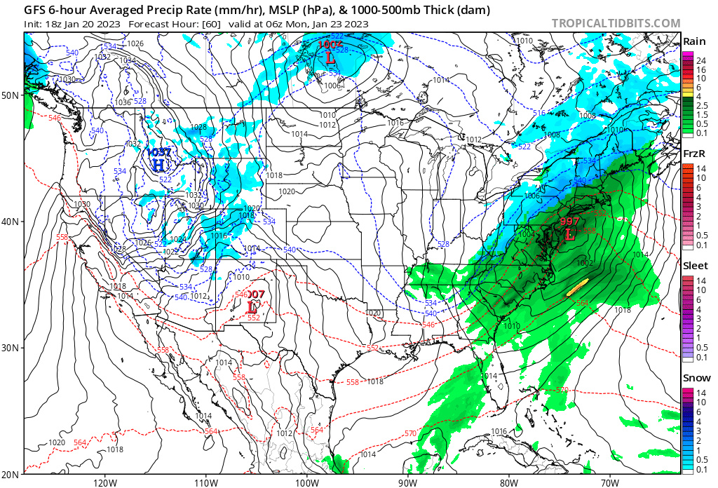
Tuesday: A clipper approaches from the west. This could tap into some Gulf moisture and try to form a secondary low pressure system. What we know at this point is that pcpn is likely w/the system, whether it's just snow showers w/the Clipper or something more substantial. It should be cold enough for snow everywhere, except possibly the immediate SE coast. W/this in mind, I have simply worded "snow likely" for Tue, w/o trying to get too cute at day 5, altho I did restrict precip to the afternoon and on. The morning looks dry. Guidance appears to not recognize what direction the winds are from, so I went well below guidance temps, and I have highs of 30-35 in my fcst.
Wednesday: Went a few deg below guidance, as cold air advection commences. Once again, sunny but cold. Highs generally in the upper 20s, except 30-32 along the I 91 corridor.
Thursday: Yet another Arctic air mass pulls right into the region. Went just a smidge below guidance. Guidance doesn't look horrible, but when we have strong departures, it is usually biased toward climo at that range, so compensated in that direction. Highs only 20-25.
There is an increasing signal for a major east coast low another couple days more down the road. Stay tuned!
Only one graphic today- the GFS' rendering of the Tuesday clipper. For now, it is kind of a middle ground solution, in that it is cold enough for snow, but just barely, and would probably produce light to low-end moderate accumulations. Of course, we have a long way to go before we get there!
On the current wx map, the cold front responsible for rain and snow across the state this morn had moved well offshore. Arctic high pressure near Lake Superior will build in and bring cold, but dry wx to the state.
Tonight: I think we can get about half a night's worth of good radiational cooling. The rest of the night will be reliant on advective cold. As we clear out, temps will fall faster later at night. For this reason, I did not go quite as cold as I could have. I went just a smidge under guidance. Expect most lows around 10, except around 5 in the far N and cooler valleys.
Tomorrow: Sunny but very cold. Guidance temps generally accepted. Highs only in the low 20s, despite sun.
Tomorrow Night/Sat: Continued cold and dry. Generally followed guidance temps, w/no real glaring reason not to. Expect highs in the mid 20s, except a few upper 20s along I 91.
Long Term: First, for Sunday, I went close to guidance on temps, w/just a tweak here and there. Generally sunny again, not quite as cold, but still cold. Highs around freezing.
Monday: Sunny, still cold. A deg or two cooler than Sunday. Highs generally near 30. Guidance was followed very closely for temps.
Tuesday: A clipper approaches from the west. This could tap into some Gulf moisture and try to form a secondary low pressure system. What we know at this point is that pcpn is likely w/the system, whether it's just snow showers w/the Clipper or something more substantial. It should be cold enough for snow everywhere, except possibly the immediate SE coast. W/this in mind, I have simply worded "snow likely" for Tue, w/o trying to get too cute at day 5, altho I did restrict precip to the afternoon and on. The morning looks dry. Guidance appears to not recognize what direction the winds are from, so I went well below guidance temps, and I have highs of 30-35 in my fcst.
Wednesday: Went a few deg below guidance, as cold air advection commences. Once again, sunny but cold. Highs generally in the upper 20s, except 30-32 along the I 91 corridor.
Thursday: Yet another Arctic air mass pulls right into the region. Went just a smidge below guidance. Guidance doesn't look horrible, but when we have strong departures, it is usually biased toward climo at that range, so compensated in that direction. Highs only 20-25.
There is an increasing signal for a major east coast low another couple days more down the road. Stay tuned!
Only one graphic today- the GFS' rendering of the Tuesday clipper. For now, it is kind of a middle ground solution, in that it is cold enough for snow, but just barely, and would probably produce light to low-end moderate accumulations. Of course, we have a long way to go before we get there!
Anyway, that's all for now! See you next week!
_GP!
_GP!
