Disc: At least there will be no more frost or freeze headlines until next fall. That we can clear out of our system. However, the fcst for this week is actually more complicated than weeks' past, as we have to deal with a cutoff low. In addition, like what's going on today, sea breezes will be a problem, since this last cold spell left the ocean and sound very chilly.
Currently: Strong high pressure offshore. Warm front near PIT. SE winds are keeping temps cooler along the S coast, up to about the Merritt Pkwy, while the I 91 corridor is warming nicely.
Tonight: Main weather question tonight is how much, if any, rain we get from the warm front. There is no question this time about the warm front clearing the area. The likelihood of showers and t-storms for very late tonight into early tmrw morn has definitely increased in recent model runs. So I will do the same for this fcst. A period of showers and t-storms will be likely during the overnight hrs. As for temps, will basically ride the dew points for lows, with humidity levels rising to near 100% and no change in air mass expected. Model guidance is in decent agreement, and will follow. So expect lows near or just above 50.
Tomorrow: Tomorrow is setting up to be an active day across the area. The SPC has placed the entire state in at least a slight risk of svr storms, with the Nrn and NW parts of the state in an enhanced risk. I'll include that map on the bottom in the "graphics" section. For simplicity, I'll make that section all about tmrw. But more on that later. Tomorrow's t-storm threat will depend largely on clearing after the early morn rains. At this point, it looks like skies should clear rather quickly. NBM temperatures have risen. With no morn clouds at all, we could really be off to the races tmrw! But even with the clouds, temps will still soar pretty good. NBM guidance was closely followed. High temps should be 75-80 degs, with the coolest readings along the S coast.
Tomorrow night/Sat... Thunderstorms probably clear the area a little after midnight. Then skies clear. Sat is a beautiful day, with warm temps and lower humidity than Fri. Due to the combination of effects of downsloping (inland) and no sea breeze (coast), I went a few degs warmer than NBM consensus. So look for highs in the mid 70s.
Long Term (Sun and beyond): Most of the weather during this period will be determined highly by the evolution of three features, none of which are that clear right now. A low pressure system going into the Great Lakes and sweeping a cold front towards the region will interact with a tropical or subtropical low offshore and a "regular" low coming up the coast, in that order. There is a lot of model chaos at this time regarding all these features, as one might expect, but the chaos factor is larger than normal, due to the fact that you have 3 pieces and they're all moving very slowly. Models do not do well with these "unconventional" setups. For now, I'll try to make the fcst as close to consensus as possible. The GFS, as is par for the course, is much further S than everything else, and doesn't get a drop of rain into the area. The UKMET is the wild extreme the other way, and fully phases everything together, creating a massive rainstorm (with high wind to boot) for the area. The GGEM and ECMWF are in between, with the GGEM closer to the GFS and the ECMWF closer to its brother (or sister, to not be politically incorrect). My fcst, for now, to follow the course of least regret, will be to comp btwn the GGEM and ECMWF and ignore the two extremes- either is psbl, but bust potnl is lwr by ignoring extremes always.
I will keep Sunday dry for now, based on the fact that the GFS has very low QPF and the NBM is totally dry. It is not out of the question to get a brief shower or sprinkle later in the day or early evening. But for now, we'll keep it dry. Based on that, and the fact that there should at least be some breaks of sun, I'll go a couple deg higher than guidance, and call for highs in the mid 60s.
Looking over the NBM guidance, I see it is showing 1"+ of rain for all of CT from the Mon-Wed timeframe. My current forecast philosophy does not go nearly that high, but keep in mind, nearly all models are showing someone getting 5-10" of rain. Right now, the model consensus is to keep that area well SW of our area, which kind of makes sense, w/high press to the N bleeding down dry air. However, models can be wrong on the placement/strength of the high and a slight wobble in any direction would move that rainfall closer or further from our state. For now, just ride what I have here and stay tuned for further changes. Temps shud be blw norm thru the pd, w/highs just in the upper 50s, moderating to the 60-65 range ltr in the pd.
Looking into the longer range, a more springlike pattern takes hold on the region. My biggest concern with taking any temps too literally in the long range is water temps. Water temps remain very cold and until they warm up, we'll have to deal with sea breezes, esepcially S of the Merritt Pkwy. So temps could be modified downward until water temps (slowly) warm up.
Sorry for briefness in the long term and lateness today. I had a data outage for about one hour that kind of messed up timing on everything.
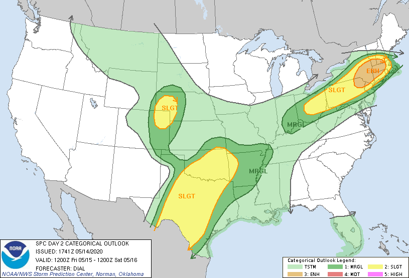
Now, let's take a graphic look at a couple of products. We're going to do things a little different today, and I'm going to post tomorrow's severe weather outlook and then the tropical weather outlook from the SPC and NHC, respectively, instead of our usual model maps. Here is tomorrow's svr wx outlook from the SPC. You can see all of CT is in at least a slgt risk of svr tstorms, with N and NW CT in an enhanced risk (the next step up). The primary threat is wind and a few tornadoes.
Currently: Strong high pressure offshore. Warm front near PIT. SE winds are keeping temps cooler along the S coast, up to about the Merritt Pkwy, while the I 91 corridor is warming nicely.
Tonight: Main weather question tonight is how much, if any, rain we get from the warm front. There is no question this time about the warm front clearing the area. The likelihood of showers and t-storms for very late tonight into early tmrw morn has definitely increased in recent model runs. So I will do the same for this fcst. A period of showers and t-storms will be likely during the overnight hrs. As for temps, will basically ride the dew points for lows, with humidity levels rising to near 100% and no change in air mass expected. Model guidance is in decent agreement, and will follow. So expect lows near or just above 50.
Tomorrow: Tomorrow is setting up to be an active day across the area. The SPC has placed the entire state in at least a slight risk of svr storms, with the Nrn and NW parts of the state in an enhanced risk. I'll include that map on the bottom in the "graphics" section. For simplicity, I'll make that section all about tmrw. But more on that later. Tomorrow's t-storm threat will depend largely on clearing after the early morn rains. At this point, it looks like skies should clear rather quickly. NBM temperatures have risen. With no morn clouds at all, we could really be off to the races tmrw! But even with the clouds, temps will still soar pretty good. NBM guidance was closely followed. High temps should be 75-80 degs, with the coolest readings along the S coast.
Tomorrow night/Sat... Thunderstorms probably clear the area a little after midnight. Then skies clear. Sat is a beautiful day, with warm temps and lower humidity than Fri. Due to the combination of effects of downsloping (inland) and no sea breeze (coast), I went a few degs warmer than NBM consensus. So look for highs in the mid 70s.
Long Term (Sun and beyond): Most of the weather during this period will be determined highly by the evolution of three features, none of which are that clear right now. A low pressure system going into the Great Lakes and sweeping a cold front towards the region will interact with a tropical or subtropical low offshore and a "regular" low coming up the coast, in that order. There is a lot of model chaos at this time regarding all these features, as one might expect, but the chaos factor is larger than normal, due to the fact that you have 3 pieces and they're all moving very slowly. Models do not do well with these "unconventional" setups. For now, I'll try to make the fcst as close to consensus as possible. The GFS, as is par for the course, is much further S than everything else, and doesn't get a drop of rain into the area. The UKMET is the wild extreme the other way, and fully phases everything together, creating a massive rainstorm (with high wind to boot) for the area. The GGEM and ECMWF are in between, with the GGEM closer to the GFS and the ECMWF closer to its brother (or sister, to not be politically incorrect). My fcst, for now, to follow the course of least regret, will be to comp btwn the GGEM and ECMWF and ignore the two extremes- either is psbl, but bust potnl is lwr by ignoring extremes always.
I will keep Sunday dry for now, based on the fact that the GFS has very low QPF and the NBM is totally dry. It is not out of the question to get a brief shower or sprinkle later in the day or early evening. But for now, we'll keep it dry. Based on that, and the fact that there should at least be some breaks of sun, I'll go a couple deg higher than guidance, and call for highs in the mid 60s.
Looking over the NBM guidance, I see it is showing 1"+ of rain for all of CT from the Mon-Wed timeframe. My current forecast philosophy does not go nearly that high, but keep in mind, nearly all models are showing someone getting 5-10" of rain. Right now, the model consensus is to keep that area well SW of our area, which kind of makes sense, w/high press to the N bleeding down dry air. However, models can be wrong on the placement/strength of the high and a slight wobble in any direction would move that rainfall closer or further from our state. For now, just ride what I have here and stay tuned for further changes. Temps shud be blw norm thru the pd, w/highs just in the upper 50s, moderating to the 60-65 range ltr in the pd.
Looking into the longer range, a more springlike pattern takes hold on the region. My biggest concern with taking any temps too literally in the long range is water temps. Water temps remain very cold and until they warm up, we'll have to deal with sea breezes, esepcially S of the Merritt Pkwy. So temps could be modified downward until water temps (slowly) warm up.
Sorry for briefness in the long term and lateness today. I had a data outage for about one hour that kind of messed up timing on everything.
Now, let's take a graphic look at a couple of products. We're going to do things a little different today, and I'm going to post tomorrow's severe weather outlook and then the tropical weather outlook from the SPC and NHC, respectively, instead of our usual model maps. Here is tomorrow's svr wx outlook from the SPC. You can see all of CT is in at least a slgt risk of svr tstorms, with N and NW CT in an enhanced risk (the next step up). The primary threat is wind and a few tornadoes.
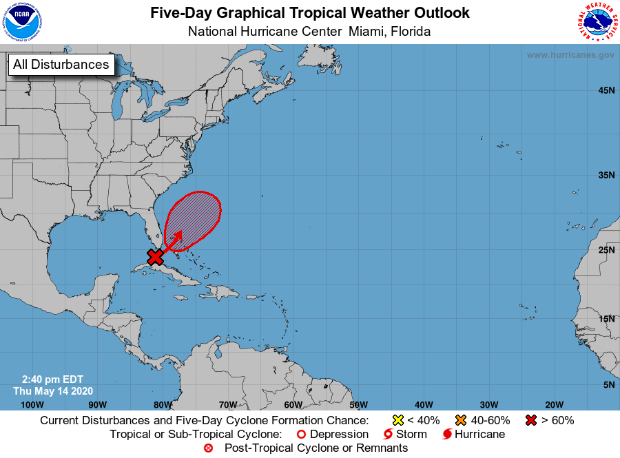
Now here is the NHC's tropical weather outlook. That blob near the Bahamas is going to become the tropical or subtropical system that may feed additional moisture into our potential rainstorm for next week.
Anyway, that's all for now! Stay safe and see you next week!
-GP!
-GP!
