Disc: A general below normal temperature regime remains in place. And it's interesting to watch, meteorologically, because even when it seems like it shouldn't happen, the atmosphere finds a new way for it to happen. So we'll see how long it can last.
Currently: Not a whole lot going on at this moment. Low pressure, the remnants of Bertha, was located over E OH. This will pump up moisture across the state even further today and could result in a brief shower at times.
Rest of today/tonight: A brief passing shower cannot be ruled out today. However, due to the lightness of any rain and very widely scattered nature of the showers, I don't feel a big mention is warranted in the fcst. Highest chc for anything occurring the further W you go.
Into tonight, a very warm and muggy night. The combination of warm air advection and an already very humid air mass leads me to go a few degrees warmer than guidance for tonight's lows. The chc of showers increases for a time around or just after midnight, but only enough in far SW CT to mention in the fcst, and even there, it's just a small chc. Lows should only be in the mid to upper 60s.
For tomorrow, I'd almost like to split the state up into two groups. For W CT, there is a chance of showers and t-storms any time from mid-afternoon on. For E CT, the day should be dry. With the actual cold front lingering so far to the W, there really isn't much chc for severe wx, as the trigger remains well W of the area. As for temps, guidance is in relatively good agreement, so I won't make too many chgs. Genly highs should be 70-75, but a few upper 70s are psbl in the I 91 corridor.
Tomorrow Night/Sat: Again, I'd almost like to split this up into two groups. Thunderstorms will be ongoing in W CT, with a 2nd round likely around midnight. In Ern CT, they will be just developing around midnight. In W CT, they should wind down by morning. In Ern CT, they should continue on and off thru the day on Sat. Guidance is in fairly good agreement regarding temps, and the state can be painted uniformly in upper 70s.
Long Term (Sunday and beyond): The main focus for weather in the long term will be in the Wednesday to Thursday time frame, as a frontal boundary meanders across the area.
In the meantime, expect a string of very beautiful days Sunday through Tuesday, as cool high pressure behind the front builds in. Mornings could be downright chilly during this period. Guidance temps will be generally accepted through the period for these days, since it is in remarkably good agreement for being this far out. The coolest day should be on Mon, with highs generally near or just above 70 degrees for most places, but staying in the upper 60s on Mon.
For Wednesday into Thursday, a warm front will attempt to move into the area. There is a lot of uncertainty during this period, regarding whether or not the front clears the area, whether or not it stalls, and if it stalls, where. For now, I need to be relatively vague with the details, so expect an unsettled pd, perhaps with multiple rounds of showers and t-storms. As far as temps, with great uncertainty regarding frontal position, and me not really having conf one way or the other, I'll just go close to guidance. So I'd xpct highs in the low 70s, for the most part, maybe a deg or two warmer on Thurs, depending on the final frontal position.
Looking into the long range, I do not expect a serious change in the overall pattern for the foreseeable future. Yes, climatological normals rise, so temps may trend upward a bit. But the overall pattern conts to favor hi press over the Canadian Maritimes, which would mean onshore flow and marine layer for our region. Until that chgs, don't look for meaningful chgs in our wx pattern. The GFS conts to produce phantom "very warm days" in the lr, but I will put no stock in that until I see meteorology to support that.
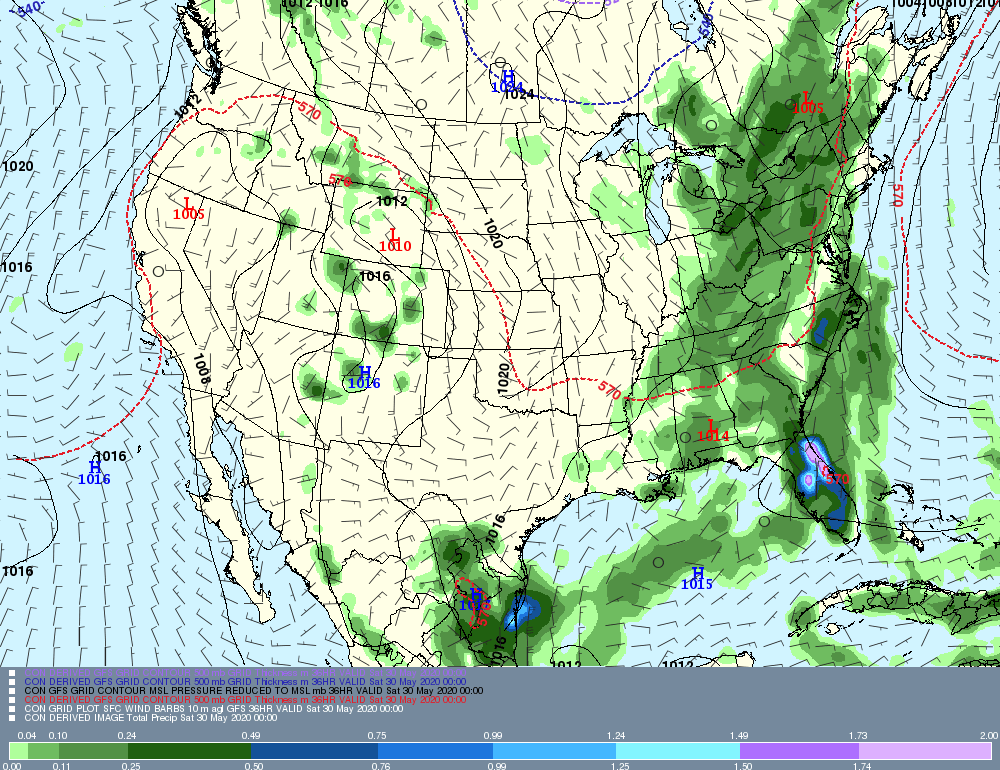
Now, let's take a look graphically at some of the systems slated to affect the area this week. First, I'll show the storms for tomorrow, but keep in mind what I said up top. It's such a slow-moving sys that we need to split the state up into two groups. Next, I'll show the Wednesday to Thursday front. As I said, that system is not set in stone, but I just want to show that it should be unsettled.
The first map, valid late Friday afternoon, shows thunderstorms just getting ready to move into Western CT. Although the system has not evolved like that yet, if you look over Northern PA, you can already almost see the storms evolving into two distinct rounds.
Currently: Not a whole lot going on at this moment. Low pressure, the remnants of Bertha, was located over E OH. This will pump up moisture across the state even further today and could result in a brief shower at times.
Rest of today/tonight: A brief passing shower cannot be ruled out today. However, due to the lightness of any rain and very widely scattered nature of the showers, I don't feel a big mention is warranted in the fcst. Highest chc for anything occurring the further W you go.
Into tonight, a very warm and muggy night. The combination of warm air advection and an already very humid air mass leads me to go a few degrees warmer than guidance for tonight's lows. The chc of showers increases for a time around or just after midnight, but only enough in far SW CT to mention in the fcst, and even there, it's just a small chc. Lows should only be in the mid to upper 60s.
For tomorrow, I'd almost like to split the state up into two groups. For W CT, there is a chance of showers and t-storms any time from mid-afternoon on. For E CT, the day should be dry. With the actual cold front lingering so far to the W, there really isn't much chc for severe wx, as the trigger remains well W of the area. As for temps, guidance is in relatively good agreement, so I won't make too many chgs. Genly highs should be 70-75, but a few upper 70s are psbl in the I 91 corridor.
Tomorrow Night/Sat: Again, I'd almost like to split this up into two groups. Thunderstorms will be ongoing in W CT, with a 2nd round likely around midnight. In Ern CT, they will be just developing around midnight. In W CT, they should wind down by morning. In Ern CT, they should continue on and off thru the day on Sat. Guidance is in fairly good agreement regarding temps, and the state can be painted uniformly in upper 70s.
Long Term (Sunday and beyond): The main focus for weather in the long term will be in the Wednesday to Thursday time frame, as a frontal boundary meanders across the area.
In the meantime, expect a string of very beautiful days Sunday through Tuesday, as cool high pressure behind the front builds in. Mornings could be downright chilly during this period. Guidance temps will be generally accepted through the period for these days, since it is in remarkably good agreement for being this far out. The coolest day should be on Mon, with highs generally near or just above 70 degrees for most places, but staying in the upper 60s on Mon.
For Wednesday into Thursday, a warm front will attempt to move into the area. There is a lot of uncertainty during this period, regarding whether or not the front clears the area, whether or not it stalls, and if it stalls, where. For now, I need to be relatively vague with the details, so expect an unsettled pd, perhaps with multiple rounds of showers and t-storms. As far as temps, with great uncertainty regarding frontal position, and me not really having conf one way or the other, I'll just go close to guidance. So I'd xpct highs in the low 70s, for the most part, maybe a deg or two warmer on Thurs, depending on the final frontal position.
Looking into the long range, I do not expect a serious change in the overall pattern for the foreseeable future. Yes, climatological normals rise, so temps may trend upward a bit. But the overall pattern conts to favor hi press over the Canadian Maritimes, which would mean onshore flow and marine layer for our region. Until that chgs, don't look for meaningful chgs in our wx pattern. The GFS conts to produce phantom "very warm days" in the lr, but I will put no stock in that until I see meteorology to support that.
Now, let's take a look graphically at some of the systems slated to affect the area this week. First, I'll show the storms for tomorrow, but keep in mind what I said up top. It's such a slow-moving sys that we need to split the state up into two groups. Next, I'll show the Wednesday to Thursday front. As I said, that system is not set in stone, but I just want to show that it should be unsettled.
The first map, valid late Friday afternoon, shows thunderstorms just getting ready to move into Western CT. Although the system has not evolved like that yet, if you look over Northern PA, you can already almost see the storms evolving into two distinct rounds.
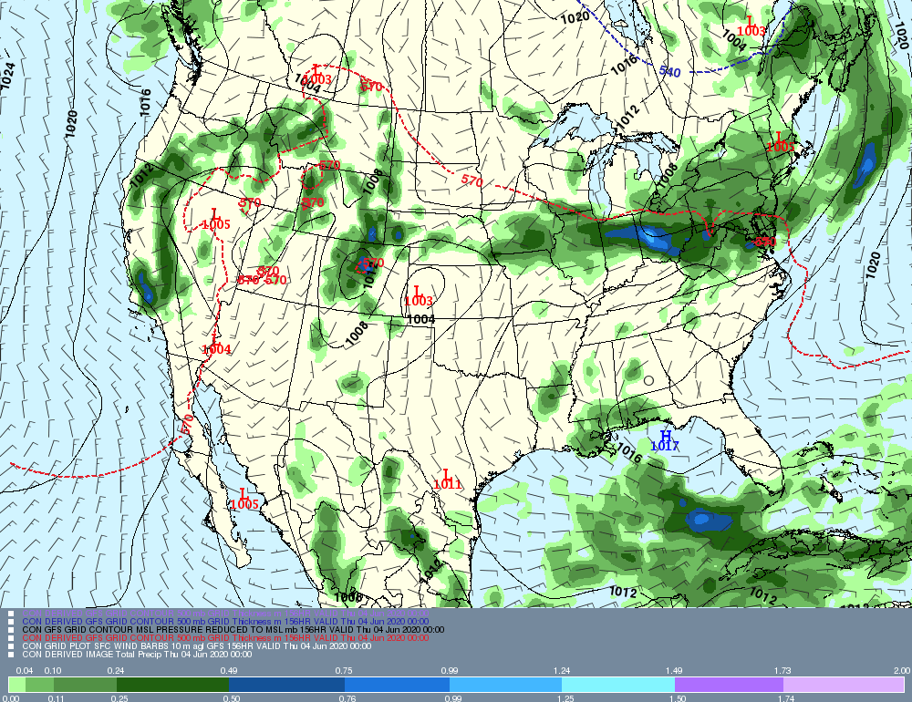
There is a whole lot going on on the next map I am about to post, valid late Wednesday afternoon. There are multiple low pressure centers, stretching from KS to New England to the Canadian Maritimes. Tracing the 570 thickness line, we can trace the warm front from the mouth of the Del Bay, thru Pittsburgh, to Chicago. You can also see how a plethora of wx solns could be psbl, ranging from vry heavy rain to a few showers. Stay tuned, as this sys gets closer, for more updts.
Anyway, that's all for now! Stay safe and see you next week!
-GP!
-GP!
