Disc: As the header states, we're finally going to feel like fall in this area very soon. However, as usual, the pattern will change in pieces.
Currently: High pressure over the Appalachians keeping the area warm and dry today. This high will keep its grip over the area today and tomorrow, before finally losing its grip later in the day on Sat.
Tonight: Temp guidance in very good agreement. W/a warm air mass in place, and not ideal radiational conditions, I am inclined to simply follow the guidance. Lows generally near 60, except for a few mid 50s in the NW hills and sheltered valleys.
Tomorrow: More of the same. I generally use NBM highs as a ceiling, unless there are other factors at work, and I will do so again tomorrow, generally subtracting a few degrees. Even so, this still gives us highs in the low to mid 70s.
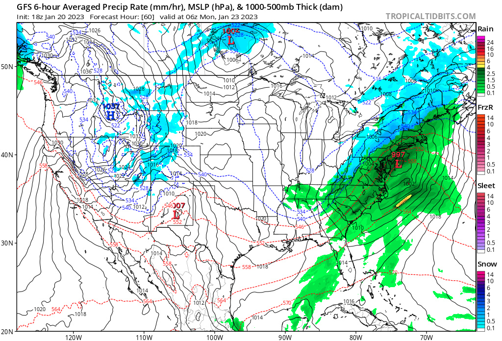
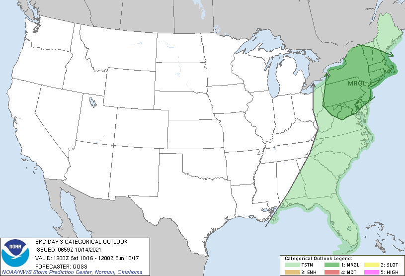
Tomorrow Night/Sat: A strong cold front will approach on Sat and bring w/it a line of t-storms. In fact, the SPC has placed the southern half of the state in a marginal risk for svr wx, which is pretty impressive for a day 3 outlook in Oct. It will depend on timing, but I would not be surprised to see strong to svr storms on Sat across the state. As for temps, guidance is close and went close to preserve continuity in the fcst, 70-75 again for highs.
Long Term- Sun and beyond: The only potential problem days are Sun and Thurs, at least during our fcst period.
Sun: Much cooler. ULL spins overhead behind the departing front. Air mass is dry, but this doesn't matter too much when pcpn mode is convective. Lapse rates are steep, convective temps are low, and the freezing level is low. This adds up to chances for showers and t-storms in the afternoon, w/stronger cells containing small hail. I went pretty close to guidance on temps. But it could very well turn out to be a day where high temps are achieved around noon or so and temps fall rapidly w/storms. If that's the case, I may be too warm on temps. Highs generally 60-65. One other note, w/a steep pressure gradient, we'll have wind gusts to 30-35 MPH adding to the chill!
Mon: Still windy and chilly. Again pretty close to guidance on temps. General highs around 60 degrees. Winds will gust to 40 MPH at times and add to the chill!
Tue: Normal temps and diminishing winds. Guidance temps accepted. Highs generally in the mid 60s, except upper 60s to near 70 along the I 91 corridor.
Wed: I chopped about 3-5 deg off guidance. A very weak cool front has appeared on modeling late Tue. There is no moisture to put any pcpn in the fcst, but it gives me pause that the NBM temps are too warm. So I'll go with 60-65, except maybe mid to upper 60s along the I 91 corridor- a few deg cooler than Tue.
Thu: Expect increasing clouds ahead of the next cold front. Due to timing and evolution concerns w/the next cold front, I have left precip out of the fcst for now. Depending on how this evolves, this may need to be inserted later on. Because of increasing clouds and a desire for continuity at latter stages of the fcst, I went a few deg under guidance for temps and left the temps on Thu the same as Wed's.
Longer Range: Models are very confused how to handle evolving system for the following weekend. Will it come thru in two pieces or will it be one bigger one? At any rate, temps look below norm, and at least one really chilly, rainy day for that weekend! Even further out, day 12-15 could get interesting w/a tropical hybrid threat of sorts! Being that it is very far out, just stay tuned for now!
For today's graphics, I have inserted the SPC day 3 outlook (SWODY3) and a graphic from the GFS showing the referenced line of t-storms. IF the timing coincides, we could potentially have our last svr wx episode until next spring!
Currently: High pressure over the Appalachians keeping the area warm and dry today. This high will keep its grip over the area today and tomorrow, before finally losing its grip later in the day on Sat.
Tonight: Temp guidance in very good agreement. W/a warm air mass in place, and not ideal radiational conditions, I am inclined to simply follow the guidance. Lows generally near 60, except for a few mid 50s in the NW hills and sheltered valleys.
Tomorrow: More of the same. I generally use NBM highs as a ceiling, unless there are other factors at work, and I will do so again tomorrow, generally subtracting a few degrees. Even so, this still gives us highs in the low to mid 70s.
Tomorrow Night/Sat: A strong cold front will approach on Sat and bring w/it a line of t-storms. In fact, the SPC has placed the southern half of the state in a marginal risk for svr wx, which is pretty impressive for a day 3 outlook in Oct. It will depend on timing, but I would not be surprised to see strong to svr storms on Sat across the state. As for temps, guidance is close and went close to preserve continuity in the fcst, 70-75 again for highs.
Long Term- Sun and beyond: The only potential problem days are Sun and Thurs, at least during our fcst period.
Sun: Much cooler. ULL spins overhead behind the departing front. Air mass is dry, but this doesn't matter too much when pcpn mode is convective. Lapse rates are steep, convective temps are low, and the freezing level is low. This adds up to chances for showers and t-storms in the afternoon, w/stronger cells containing small hail. I went pretty close to guidance on temps. But it could very well turn out to be a day where high temps are achieved around noon or so and temps fall rapidly w/storms. If that's the case, I may be too warm on temps. Highs generally 60-65. One other note, w/a steep pressure gradient, we'll have wind gusts to 30-35 MPH adding to the chill!
Mon: Still windy and chilly. Again pretty close to guidance on temps. General highs around 60 degrees. Winds will gust to 40 MPH at times and add to the chill!
Tue: Normal temps and diminishing winds. Guidance temps accepted. Highs generally in the mid 60s, except upper 60s to near 70 along the I 91 corridor.
Wed: I chopped about 3-5 deg off guidance. A very weak cool front has appeared on modeling late Tue. There is no moisture to put any pcpn in the fcst, but it gives me pause that the NBM temps are too warm. So I'll go with 60-65, except maybe mid to upper 60s along the I 91 corridor- a few deg cooler than Tue.
Thu: Expect increasing clouds ahead of the next cold front. Due to timing and evolution concerns w/the next cold front, I have left precip out of the fcst for now. Depending on how this evolves, this may need to be inserted later on. Because of increasing clouds and a desire for continuity at latter stages of the fcst, I went a few deg under guidance for temps and left the temps on Thu the same as Wed's.
Longer Range: Models are very confused how to handle evolving system for the following weekend. Will it come thru in two pieces or will it be one bigger one? At any rate, temps look below norm, and at least one really chilly, rainy day for that weekend! Even further out, day 12-15 could get interesting w/a tropical hybrid threat of sorts! Being that it is very far out, just stay tuned for now!
For today's graphics, I have inserted the SPC day 3 outlook (SWODY3) and a graphic from the GFS showing the referenced line of t-storms. IF the timing coincides, we could potentially have our last svr wx episode until next spring!
Anyway, that's all for now! See you next week!
-GP!
-GP!
