Disc: A textbook winter pattern, with major blocking up north and troughing over nearly the entire CONUS is about to set in, and it may start off w/a little "appetizer" event Sunday night.
Currently: Wx basically nil. High press over SE VA departing. The 1043 high that is currently over the ON/QC border in Central Canada is going to become a bigger player in our wx.
Tonight: Went a few deg below guidance thruout the state. It may turn out even colder in spots than what I am fcstg. I really don't see anything to hinder radiational cooling. Lows generally 20-25. There could be a few warmer spots over urban areas, but I tried to keep it pretty simple. Early breezes diminish as we go thru the night.
Tomorrow: Probably good downsloping day. Clouds increase, but mostly of the high variety, so that shouldn't have much impact on temps. Highs generally 40-45. Went a few deg above guidance to account for downsloping.
Tomorrow Night/Sun: Precip develops Sun aftn, could start as snow, then change to rain and sleet for a time everywhere, esp near the S coast. Temps are a bit tricky because they could rise a bit quickly in the morn if there is any sun, then settle or fall. I went a couple deg under guidance, generally upper 30s for most.
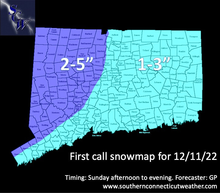
Sun night, pcpn turns to snow everyone from NW to SE. Snow then winds down and tapers off by dawn. A map will be posted. Accumulations generally 1-3 along the coast and central/eastern CT and up to 2-5 in western CT with highest in coldest spots. There could be a surprise 6" report somewhere. Soundings are unstable and suggest banding. It is also possible that some places along the coast see very little, esp E of I 91, if pcpn stays fairly light.
Long Term: Pattern turns increasingly colder and more wintry, with winter storm chances.
Monday: Cold and sunny behind departing coastal low. Wind does not look exciting. Went pretty close to guidance on temps, just smoothed it out, near 40 for everyone.
Tuesday: Still chilly and sunny. Again went close to guidance, just a bit of smoothing out. Kept everyone in the low 40s.
Weds: Confidence starts to erode here. The GGEM gets pcpn in here, but it seems to be a fast outlier. For now, will keep Wed dry and just go increasing clouds. Once again, followed guidance pretty closely, and just smoothed things out. Generally near 40 looks good thruout the state.
Thurs: a storm sys approaches. Lots of uncertainty here. The GGEM and ECMWF have both trended colder and now show mostly frozen for everyone. The GFS has trended way south and is now suppressed. It is not impossible, if the ULL retrogrades into BOS harbor like that. For that reason, I capped POPs at high chance. Right now, for precipitation type, I have mostly frozen. I went colder than NBM, and I followed the same logic on temps, capping highs in the upper 30s. It's hard to really try to time this, since there's a big timing diffs in the models. But for now, a consensus would be a midday(ish) start.
Fri: Still low confidence, surrounding the departing storm system. Again, consensus would be to pull outta here Fri morn, but ECMWF lingers pcpn longer, so will keep low chance POPs all day. Again, PTYP prob mainly frozen. High temps are a bit lower than guidance, generally near 40, but kept mid 30s NE CT, as pcpn prob lingers there longer.
Not much to say about the pattern in the LR, aside from the fact that it turns progressively colder and prob stays stormy.
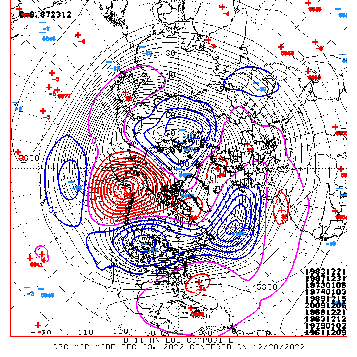
CPC map posted again... look at the below norm heights across virtually the entire CONUS!
See you again next week!
-GP!
Sun night, pcpn turns to snow everyone from NW to SE. Snow then winds down and tapers off by dawn. A map will be posted. Accumulations generally 1-3 along the coast and central/eastern CT and up to 2-5 in western CT with highest in coldest spots. There could be a surprise 6" report somewhere. Soundings are unstable and suggest banding. It is also possible that some places along the coast see very little, esp E of I 91, if pcpn stays fairly light.
Long Term: Pattern turns increasingly colder and more wintry, with winter storm chances.
Monday: Cold and sunny behind departing coastal low. Wind does not look exciting. Went pretty close to guidance on temps, just smoothed it out, near 40 for everyone.
Tuesday: Still chilly and sunny. Again went close to guidance, just a bit of smoothing out. Kept everyone in the low 40s.
Weds: Confidence starts to erode here. The GGEM gets pcpn in here, but it seems to be a fast outlier. For now, will keep Wed dry and just go increasing clouds. Once again, followed guidance pretty closely, and just smoothed things out. Generally near 40 looks good thruout the state.
Thurs: a storm sys approaches. Lots of uncertainty here. The GGEM and ECMWF have both trended colder and now show mostly frozen for everyone. The GFS has trended way south and is now suppressed. It is not impossible, if the ULL retrogrades into BOS harbor like that. For that reason, I capped POPs at high chance. Right now, for precipitation type, I have mostly frozen. I went colder than NBM, and I followed the same logic on temps, capping highs in the upper 30s. It's hard to really try to time this, since there's a big timing diffs in the models. But for now, a consensus would be a midday(ish) start.
Fri: Still low confidence, surrounding the departing storm system. Again, consensus would be to pull outta here Fri morn, but ECMWF lingers pcpn longer, so will keep low chance POPs all day. Again, PTYP prob mainly frozen. High temps are a bit lower than guidance, generally near 40, but kept mid 30s NE CT, as pcpn prob lingers there longer.
Not much to say about the pattern in the LR, aside from the fact that it turns progressively colder and prob stays stormy.
CPC map posted again... look at the below norm heights across virtually the entire CONUS!
See you again next week!
-GP!