Disc: A brief, but intense Arctic blast effects the state thru tomorrow, then we warm up, but winter may return at the end of the week or next weekend???
Currently: Arctic front well offshore. Strong winds marking the arrival of CAA. Winds have been very impressive, as we've had three gusts over 40 MPH here at the office!
Tonight: I went well under guidance, as core of Arctic air moves in. My only concern is that the core of the cold is really here within a few hrs of midnight. However, winds diminish a bit later at night, so that could be compensated for by radiational cooling We'll see. Overall, I generally have most of the state painted in single digits BELOW zero! It is possible Tolland and Windham get to -10! It is also possible the immediate S coast does not get to zero, but even they'll be close!
Tomorrow: Went a touch above guidance. Very rapid recovery, as high pressure slides offshore. Howver, given our starting point, it will stay quite cold, with highs only in the mid to upper 20s. Winds continue to diminish, so wind chills will be close to actual temps.
Tomorrow Night/Sun: I went below guidance by a couple deg, as NBM guidance appears to think cloud cover is very thin. While this is possible, the sun angle is still pretty low. There will also be some onshore flow off the cold LI sound in the afternoon on the S coast. Highs generally near 40. In the normally warmer (during the day) CT Valley locations, I went near guidance, and have low to mid 40s there.
Long Term: Mostly quiet period, things get more unsettled in the 2nd half of the period, and perhaps more interesting toward the end of the period.
Mon: W/wind flow turning more land-based and clearing skies, I felt safe going very close to guidance. High temps generally in the mid to upper 40s.
Tue: Wind flow looks lighter. That's the only major change I can see between Mon and Tue. So I made one adjustment to the fcst for Tue, and that is to go a bit cooler than guidance along the immediate S coast, w/aftn sea breezes possible. So highs generally mid to upper 40s, but 40-45 along the S coast.
Wed: I went a bit cooler than guidance everywhere. A cold front approaches, so clouds increase ahead of it, along w/the chance for a brief shower. I erred on the side of caution w/regards to temps. if clouds are delayed, it could be warmer than my fcst, as we'd get into the warm surge ahead of the cold front. But for now, just to be safe, I have the entire state painted in upper 40s.
Thu: The storm slated for this period has trended faster. Faster means less wintry, as cold air really won't have a chance to dig in. So we'll need to watch trends, as a slower storm could mean wintry wx prospects. For now, I just broadbrushed rain Thu into early Fri.
A few things could happen: This could be a mainly overnight and morning(s) event. where most of the day Thu is relatively dry. However, even if this happens, Thu is drizzly, showery, and dank. This could trend slower impacting more of Fri, which would introduce wintry wx into the area. For now, I went w/the faster solution, since snow hasn't worked out much this season.
Long Range: Maybe it's my eyes after trying to find winter for so long, maybe it's Punxy Phil's prediction, but it kind of looks like winter wants to stay a bit in the longer range, but we'll see. We could also kick it off w/some type of wintry event around Big Game Sun or early the next week. Way too early to tell, esp the way we've gone this winter, but we'll see!
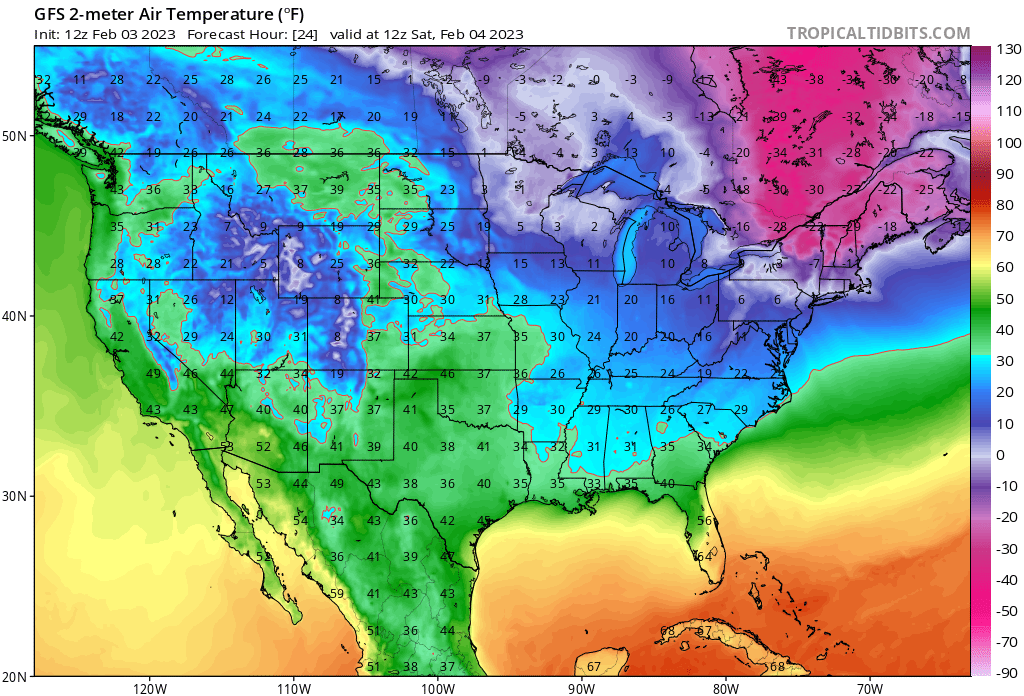
Only one graphic today- GFS temps at 12Z tomorrow. Fcst lows from that model are a couple deg colder!
Currently: Arctic front well offshore. Strong winds marking the arrival of CAA. Winds have been very impressive, as we've had three gusts over 40 MPH here at the office!
Tonight: I went well under guidance, as core of Arctic air moves in. My only concern is that the core of the cold is really here within a few hrs of midnight. However, winds diminish a bit later at night, so that could be compensated for by radiational cooling We'll see. Overall, I generally have most of the state painted in single digits BELOW zero! It is possible Tolland and Windham get to -10! It is also possible the immediate S coast does not get to zero, but even they'll be close!
Tomorrow: Went a touch above guidance. Very rapid recovery, as high pressure slides offshore. Howver, given our starting point, it will stay quite cold, with highs only in the mid to upper 20s. Winds continue to diminish, so wind chills will be close to actual temps.
Tomorrow Night/Sun: I went below guidance by a couple deg, as NBM guidance appears to think cloud cover is very thin. While this is possible, the sun angle is still pretty low. There will also be some onshore flow off the cold LI sound in the afternoon on the S coast. Highs generally near 40. In the normally warmer (during the day) CT Valley locations, I went near guidance, and have low to mid 40s there.
Long Term: Mostly quiet period, things get more unsettled in the 2nd half of the period, and perhaps more interesting toward the end of the period.
Mon: W/wind flow turning more land-based and clearing skies, I felt safe going very close to guidance. High temps generally in the mid to upper 40s.
Tue: Wind flow looks lighter. That's the only major change I can see between Mon and Tue. So I made one adjustment to the fcst for Tue, and that is to go a bit cooler than guidance along the immediate S coast, w/aftn sea breezes possible. So highs generally mid to upper 40s, but 40-45 along the S coast.
Wed: I went a bit cooler than guidance everywhere. A cold front approaches, so clouds increase ahead of it, along w/the chance for a brief shower. I erred on the side of caution w/regards to temps. if clouds are delayed, it could be warmer than my fcst, as we'd get into the warm surge ahead of the cold front. But for now, just to be safe, I have the entire state painted in upper 40s.
Thu: The storm slated for this period has trended faster. Faster means less wintry, as cold air really won't have a chance to dig in. So we'll need to watch trends, as a slower storm could mean wintry wx prospects. For now, I just broadbrushed rain Thu into early Fri.
A few things could happen: This could be a mainly overnight and morning(s) event. where most of the day Thu is relatively dry. However, even if this happens, Thu is drizzly, showery, and dank. This could trend slower impacting more of Fri, which would introduce wintry wx into the area. For now, I went w/the faster solution, since snow hasn't worked out much this season.
Long Range: Maybe it's my eyes after trying to find winter for so long, maybe it's Punxy Phil's prediction, but it kind of looks like winter wants to stay a bit in the longer range, but we'll see. We could also kick it off w/some type of wintry event around Big Game Sun or early the next week. Way too early to tell, esp the way we've gone this winter, but we'll see!
Only one graphic today- GFS temps at 12Z tomorrow. Fcst lows from that model are a couple deg colder!
That's all for now! See you next week!
-GP!
-GP!
